It primarily determines the volume in which turbulence is active and into which constituents, which are emitted near the surface, are dispersed. The height of the mixing layer typically varies between 50 and 2500 m for the Netherlands, depending on, for example, the season, time of day, the synoptic situation and local conditions as orography, land use and surface roughness.

The research presented here is performed as part of the project Integrated observations and modelling of Greenhouse Gas budgets at the national level in the Netherlands1), (hereafter ME2 project). This project is executed in the frame of the programme Besluit Subsidies Investeringen Kennisinfrastructuur – Klimaat voor Ruimte (BSIK-KvR)2). The overall goal of the ME2 project is to improve the description of the temporal and spatial distribution of greenhouse gases in the Netherlands. One of the work packages focuses on the influence of the dynamics and mixing processes in the Planetary Boundary Layer (PBL) on greenhouse gas concentrations that are observed in the PBL. An important task within this work package is the continuous monitoring of PBL height and the driving variables for PBL growth (e.g., sensible heat flux) at several locations in the Netherlands. KNMI actively participates in the ME2 project, together with a number of other Dutch research institutes and universities.
A lidar (LIght Detection And Ranging) system has been recognised as a suitable instrument to detect the boundaries of aerosol layers3,4,5). A lidar system transmits laser pulses vertically and measures the backscattered signal. The strength of the backscattered signal depends on the amount of scattering particles in a volume at a certain distance from the instrument. The time interval between transmission and reception of the signal determines the distance. The backscatter profile is the backscattered signal as a function of height.
A ceilometer is a commercial lidar system that is primarily used for the detection of cloud base heights for aviation and meteorology. Ceilometers are designed to operate and measure continuously and require little maintenance. KNMI operates Vaisala LD-40 ceilometers (Figure 1) at about 25 locations in its meteorological observation network in the Netherlands.
The presence of aerosols can be detected in the backscatter profile of a ceilometer. As aerosols are mainly emitted at the surface, the concentration is generally higher in the mixing layer than in the free troposphere. Therefore the MLH estimation by lidar systems is based on the detection of the sharp decrease (gradient) in aerosol backscatter at the top of the mixing layer. This decrease marks the interface between the aerosol containing mixing layer and the relatively clean free troposphere. Other commonly used instruments for the estimation of the mixing layer height are SODARs (SOund Detection And Ranging), wind profilers and radiosondes6). These instruments use gradients in the acoustic refractive index, radar refractive index and in the temperature and humidity profiles respectively, to determine the MLH.
The ceilometer MLH algorithm7) applies a Haar wavelet transform to locate the strong negative gradient in the aerosol backscatter at the top of the mixing layer8) (see Figure 2). The wavelet algorithm is applied to the 10 minute averaged, range- and overlap-corrected, backscatter profile within a vertical domain of 90-3000 m. Furthermore the upper range limit is restricted by the lowest cloud base and the SNR<1 height. The latter is the height where the SNR (signal-to-noise-ratio) drops below 1, indicating the range for which the backscatter signal is assumed to be reliable enough for MLH estimation. The algorithm is able to estimate up to two mixing layer heights, referred to as MLH1 and MLH2. A quality index has been introduced to make a first estimate of the reliability of the derived mixing layer height. This index is related to the difference in backscatter just below and above the estimated mixing layer height. Time series of the MLH detection hold information on the consistency of the results.
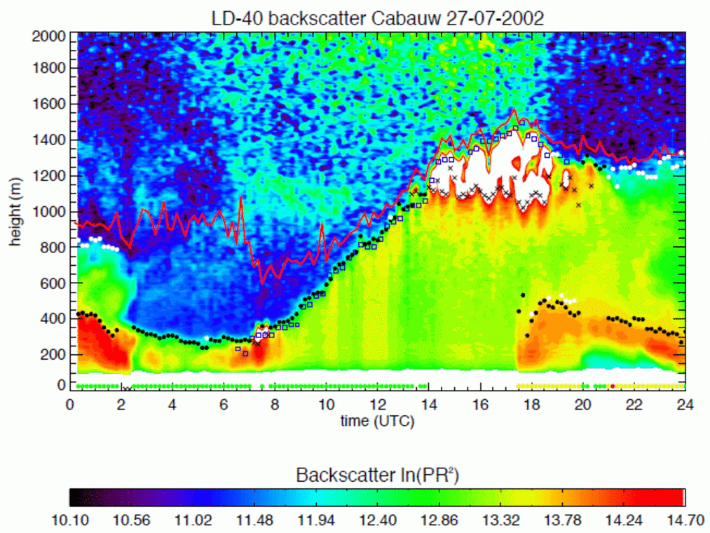
The backscatter contour plot and resulting MLH estimates for Cabauw on July 27th, 2002 are shown in Figure 3. The development of a convective mixing layer is clearly observed, with a sharp and strong decrease in aerosol backscatter between the mixing layer and the free atmosphere. The resulting MLH time series shows a low variability between successive points. The build up of the convective layer is disturbed around 1400 UTC by the development of cumulus clouds on top of the mixing layer. These clouds restrain the algorithm from detecting the mixing layer height successfully. Around 1730 UTC a new aerosol layer is observed, which extends between 200 and 500 m above ground level during the evening. The occurrence of this layer coincides with a change in wind direction and marks the advection of an air mass containing aerosol from a different source area. During the first two and last three hours of this day, a secondary MLH is detected above the elevated aerosol layer. This secondary MLH is associated with the top of the so-called residual layer.
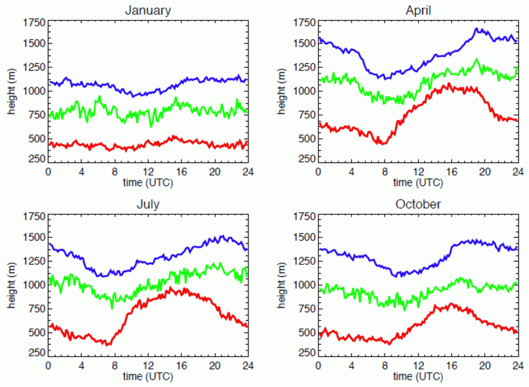
Six years of backscatter profiles (2000-2005) from the LD-40 at the KNMI test field in De Bilt have been used to assess the overall performance of the ceilometer MLH algorithm with respect to the monthly availability and reliability of the MLH estimates7). The monthly mean diurnal cycle of the mixing layer heights and the SNR<1 height for January, April, July and October are shown in Figure 4, representative for the winter, spring, summer an autumn season, respectively. The typical shape of the development of a convective mixing layer is observed, as well as an evident annual cycle of the amplitude of the diurnal variation. However, the monthly mean MLH1 during daytime observed for spring and summer months is lower than expected. Further research showed that the ceilometer is unable to detect most of the deep mixing layers heights, especially under strong convective conditions. One must keep in mind that the ceilometer MLH algorithm needs sufficiently high aerosol concentrations in order to be able to derive a MLH. Since the backscatter signal of aerosol is much less than for clouds, the sensitivity and hence the range of a ceilometer for MLH detection is much less than for cloud base detection. The overall detection rate for MLH1 is between 42 % (December) and 60 % (June). However, the relative contribution of ‘Weak’ and ‘Poor’ detections increases with increasing detection rate. Hence, the higher daytime values of mixing layer height as observed for April and July in Figure 4 generally coincide with lower quality indices. This is related to the enhanced vertical variability in the backscatter signal and hence the increased chance on a faulty MLH detection on a less pronounced jump in the aerosol backscatter. The most important reason for the lower detection rates during the winter months is the frequent occurrence of weather conditions, like fog, rain and clouds, which inhibit a successful MLH detection. Note that in case of boundary layer clouds the cloud base height can sometimes be used as an approximation for the MLH.

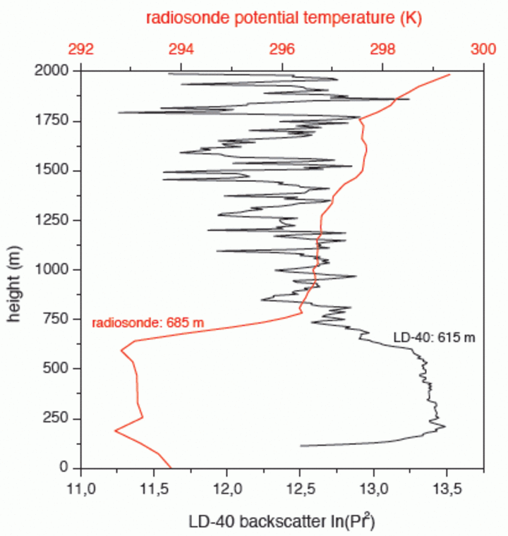
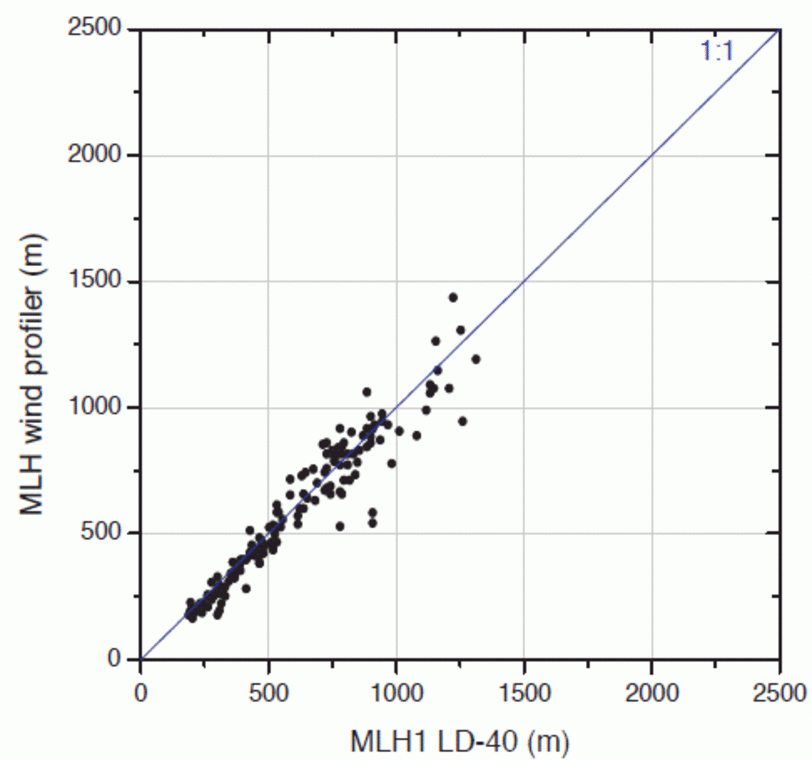
A comparison of MLHs estimated by the MLH algorithm and the Richardson bulk method applied to 1200 UTC radiosonde profiles in De Bilt, is shown in Figure 5. The agreement between the ceilometer and radiosonde is poor if all MLH estimates are considered. In particular for values of LD-40 MLH above 500 m much scatter is observed. The MLH derived by the radiosonde methods is mostly higher with respect to the LD-40 estimates. A major improvement in agreement between the LD-40 and the radiosonde MLH is seen when only the detections with the highest quality index are taken into account. As a consequence of this selection, the number of points in the scatter plot decreases from 41 % to 16 % of the total number of used radiosoundings in the considered period. Very consistent results are found in the comparison of LD-40 and wind profiler MLH in Cabauw on eight days in August 2001, as shown in Figure 6.
An automated method was developed to derive the mixing layer height from the backscatter profiles measured with a Vaisala LD-40 ceilometer. The detection of the mixing layer height is based on the (strong) decrease in aerosol backscatter at the transition from the polluted mixing layer to the relatively clean free atmosphere. Although the detection is feasible by the method presented, limitations exist. The reliability of the MLH detection is strongly connected to the variability of the aerosol backscatter signal in height in the mixing layer. Profiles that show a fairly constant and sufficient amount of aerosol backscatter generally give a reliable detection of MLH. This mainly occurs when the mixing layer grows not too deep, e.g. in a shallow wintertime mixing layer. Furthermore, problems sometimes occur during the afternoon decay of the convective mixing layer or for the nocturnal mixing layer. The problems encountered are partly caused by instrumental limitations. As commercial ceilometers were originally developed for cloud base detection, the sensitivity to aerosols is lower than for research lidars. Users must keep in mind that the presence of atmospheric constituents may be also caused by other sources than local ones. The quality index gives a good indication of the reliability of the MLH detection.
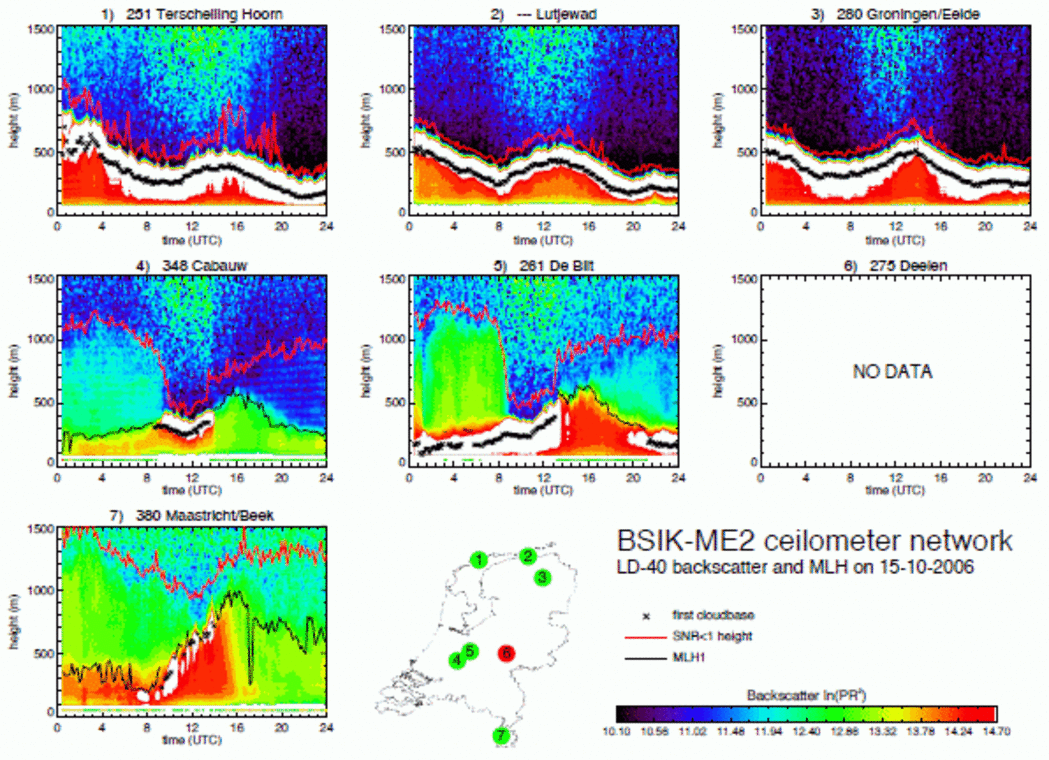
The BSIK-ME2 measurement campaign is scheduled to be executed from July 2007 to July 2009. As a part of this campaign, KNMI will store and process backscatter data from six LD-40 ceilometers. A good co-location with scintillometry instruments operated by Wageningen University (WUR) was aimed for in the set-up of the ceilometer network. Scintillometers measure the area averaged sensible heat flux, which is the driving mechanism behind the development of the daytime mixing layer. Hence, the spatial variation of the MLH can be coupled directly to a variation in the sensible heat flux. The six selected locations are Hoorn (Terschelling), Eelde, Cabauw, De Bilt, Deelen and Maastricht. A quicklook of backscatter data and the resulting MLHs for this small network on October 15th, 2006 is shown in Figure 7.
During the campaign the usefulness of the ceilometer MLH product will be further evaluated. Depending on the results of the evaluation the implementation of the wavelet algorithm in the sensor interface of the KNMI operational ceilometer network will be considered. After such an implementation the MLH for all ceilometer locations in the Netherlands would become available to users every 10 minutes in near real-time.