Scatterometers provide high resolution all-weather wind vector fields over the sea. Wind speed and wind direction are provided with high quality under all weather conditions.
At present there are three types of scatterometers operational. The all-weather ESA ERS scatterometer observations have proven its significant impact for the forecasting of fast developing and severe weather. Moreover, scatterometer wind fields are provided on the ocean eddy scale and are important for driving the ocean’s motion. As a consequence, oceanographic applications have been initiated using winds from the SeaWinds scatterometer on the QuikScat satellite. Together, ASCAT, ERS-2 and SeaWinds provide good coverage over the oceans twice a day. They are used routinely in marine and weather forecasting. Below, the KNMI contribution to the EUMETSAT Satellite Application Facilities (SAFs), the ASCAT calibration, high spatial resolution wind products and their application are elaborated. In the coming years KNMI continues developing high resolution operational products for coastal areas.
The EUMETSAT Advanced Scatterometer ASCAT on MetOp-A was launched on 19 October 2006 as the third wind scatterometer in space joining up with the ESA ERS-2 and the NASA/NOAA SeaWinds scatterometers. China and India also plan to launch scatterometers. At the moment KNMI provides a regional quasi real-time and a global near-real time data stream for respectively the ERS-2 and the SeaWinds scatterometer on QuikScat. MetOp-A complements these global scatterometer missions with ASCAT. A regional quasi real-time ASCAT dissemination and a near real-time global service are started through KNMI. In this way continuity of both wind services is provided to the operational meteorological and oceanographic communities for another period of 15 years in the MetOp era.
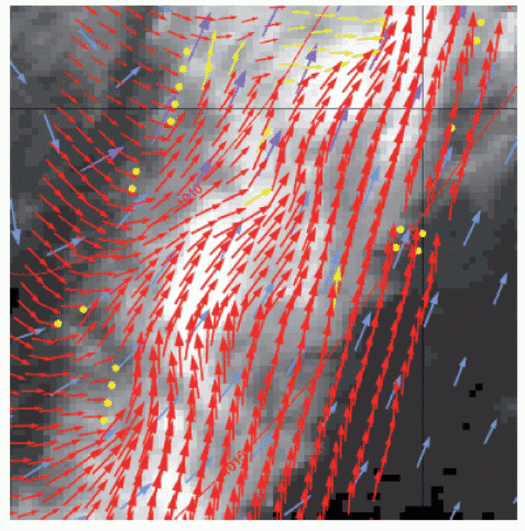
Scatterometers uniquely define the mesoscale wind vector field at the sea surface by measuring the radar backscatter signal from wind-generated cm-sized, so-called, gravity-capillary sea waves. Because of the wavelength (5 cm), the signal of ASCAT is not affected by rain, and so it is an ‘all-weather’ system. The all-weather capability of the ASCAT scatterometer provides unique wind field products of the most intense and often cloud-covered wind phenomena, such as polar front disturbances and tropical cyclones (for example, see Figure 1). As such, it has been demonstrated that scatterometer winds are extremely useful in the prediction of extra-tropical cyclones and tropical cyclones1). Moreover, the high-resolution near-surface winds as provided by scatterometers are very relevant because these winds drive the ocean water circulation, which in turn plays a major role in the climate system and in marine life and its exploitation (e.g., fishery).
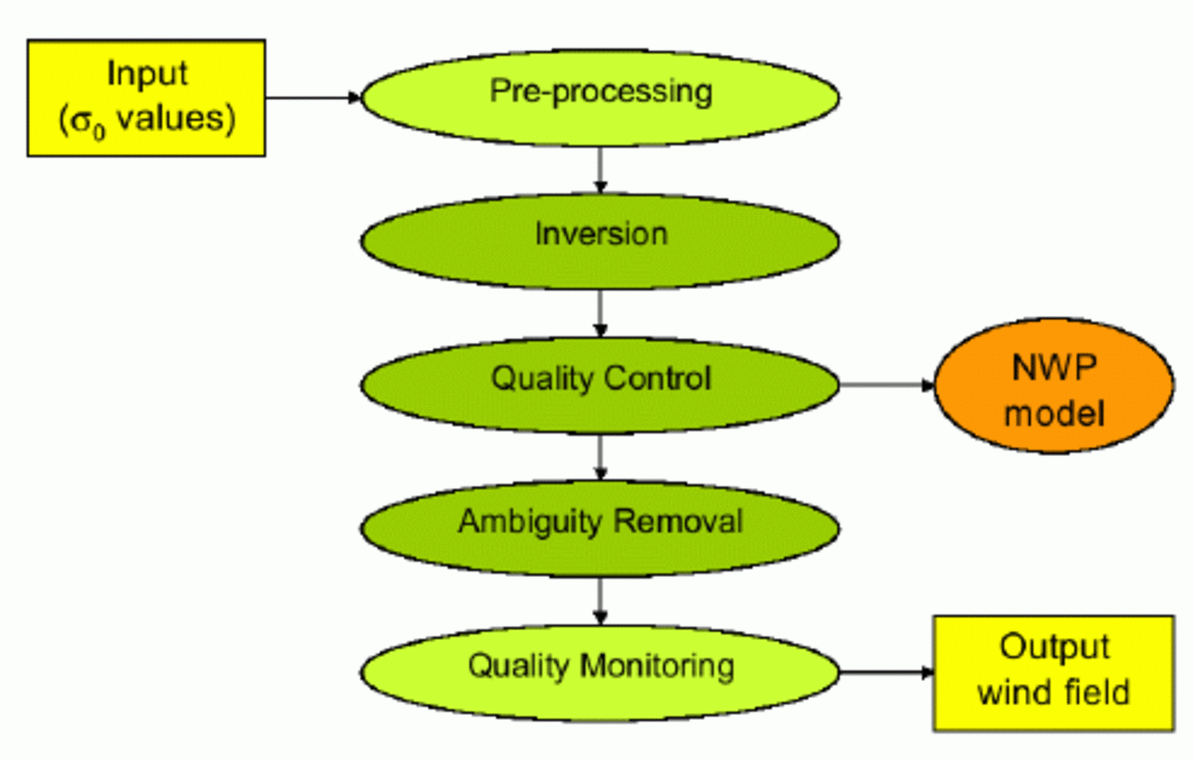
The methodology developed for the successful application and assimilation of ERS winds in Numerical Weather Prediction (NWP) (see Figure 2) has been generalised at KNMI to include the new scatterometer concepts, such as SeaWinds and ASCAT. In the coming years, further progress in high resolution processing, closer to the coast, and with improved geophysical interpretation will be elaborated.
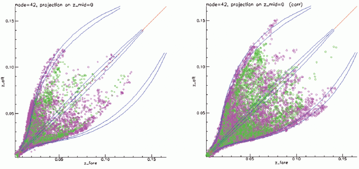

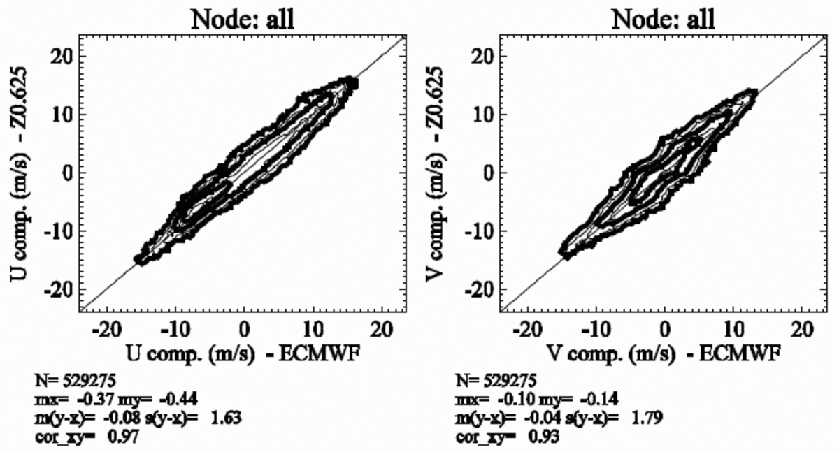
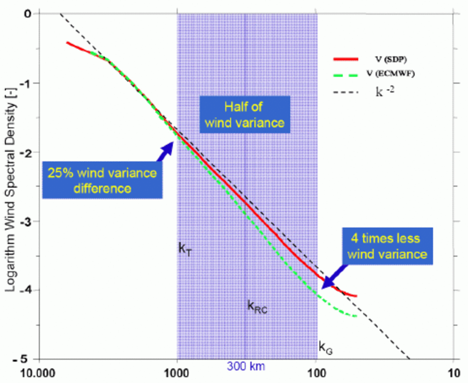
Figure 5: Wind variance versus spectral wave number k for a climatological spectrum (k-2 ), for the KNMI SeaWinds 25-km wind product (SDP), and for collocated NWP 10-m winds (ECMWF) on a 10log-10log scale5). With respect to the SeaWinds curve, the NWP spectral curve drops faster in variance over the blue shaded spectral range of corresponding wavelengths from 1000 km to 100 km.
The geophysical knowledge on water surface radar backscatter obtained from the ERS scatterometer observations in the radar C band is used in calibrating ASCAT. The empirical C-band Geophysical Model Function (GMF), called CMOD52), relates ERS scatterometer backscatter data to wind. Moreover, the geophysical uncertainties in the interpretation of scatterometer winds have been modelled in detail3). This provides insight in the coherence of the three scatterometer measurements, one by each of the three radar beams, in a Wind Vector Cell (WVC). In a first calibration step this coherence is predicted by CMOD5 and tested against the combined probability density function (PDF) of the ASCAT measurement data and its coherence (Figure 3). In a second step, a controlled distribution of backscatter measurements of ASCAT may be simulated by using a reference 10-m wind data set and CMOD5, and be compared to the collocated set of ASCAT measurements. By performing such comparisons, KNMI has computed ‘calibration’ data to correct the backscatter measurements that, after wind processing, lead to ASCAT winds well within the user quality specifications4). Figure 4 gives an example. In the remaining MetOp-A commissioning period EUMETSAT will work together with KNMI towards calibrated radar backscatter data, improving the quality of the current ASCAT demonstration wind stream.
The spatial consistency and detail in scatterometer sea surface winds is unprecedented. In many applications, such as storm surge and wave prediction, marine warnings and ocean forcing, NWP analysis winds are used as input, lacking mesoscale detail. For both operational real-time marine applications and oceanographic research it is important to characterise the differences between the scatterometer and NWP products. The difference in wind variance at smaller scales between SeaWinds and the ECMWF NWP model as shown in Figure 5 illustrates the general deficiency of NWP models. In particular, marked sharp structures in the scatterometer winds that are not represented in NWP analyses often appear near islands and in coastal regions. The smaller scales in the scatterometer winds suggest that ocean eddies which are of typical 10-km size are forced much more effectively in models by a scatterometer wind field than by NWP winds.
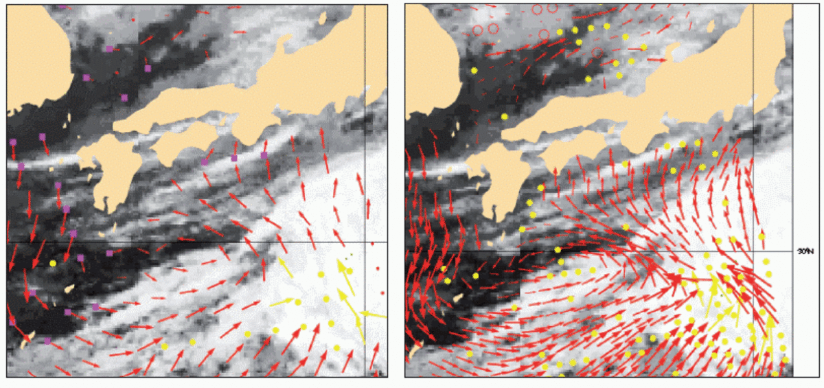
The standard KNMI 100-km QuikScat product has been developed for NWP assimilation. It is verified to compare best with independent ECMWF NWP winds and is thus very suitable for NWP assimilation. At higher resolutions (< 100 km) more random noise is present in SeaWinds data5). Fortunately, SeaWinds noise reduction at 25 km resolution can be achieved by implementing the so-called Multiple Solution Scheme (MMS6)). This scheme uses wind vector probability information from the wind inversion step7) (Figure 2) in combination with 2D-Variational Ambiguity Removal, 2D-VAR. 2D-VAR implies a spatial meteorological balance in the near-surface wind by applying constraints on rotation and divergence8). The improvements in MSS are mainly due to the reduction of occasional erratic noise, while coherent mesoscale structures remain present and become more visible. In Figure 6 the MSS 25-km product is shown on the right. It is clear that with respect to the left panel (at 100 km resolution) important mesoscale details, potentially useful for short range weather forecasting and nowcasting, become visible.
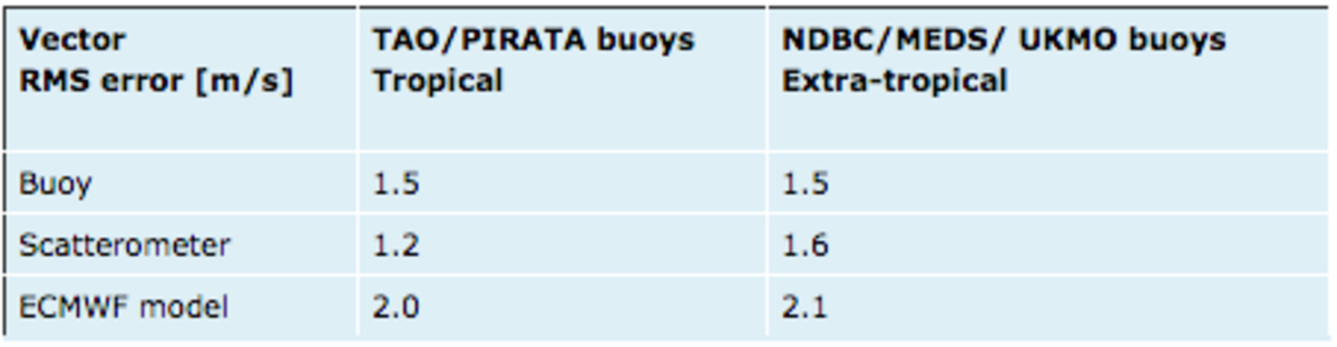
Different wind data sources represent different spatial scales: NWP models lack deterministic scales below 100 km, scatterometers present scales down to 25 km and in situ measurements are local. On the other hand, in terms of application, a local wind is only locally useful, while a field of cell-averaged winds comprehensively represents the conditions over a large area. Therefore, these wind observations cannot be mutually compared without taking into account spatial representation and the wind variability spectrum. Stoffelen and co-authors9,10) included these aspects in a triple collocation comparison method and derived wind observation error measures. Table 1 presents recent values obtained from this study, showing the reasonable quality of NWP data in the extratropics, but relatively poor quality in the tropics. Buoy data appear rather inaccurate, since the error is computed for the space-averaged wind in a 50-km size scatterometer cell. As a consequence, the spatial wind variability on scales smaller than 50 km is here considered to be part of the buoy observation wind error.
Scatterometer winds are used by all major NWP centres and by the oceanographic community. At KNMI efforts are currently ongoing to assimilate high resolution ASCAT scatterometer data in the NWP High-Resolution Limited Area Model (HiRLAM) and in the second half of 2007 operational implementation is planned. Emphasis is put on the assimilation of high-resolution products and on exploitation of winds on the short range, particularly for extreme weather events. Moreover, today these winds are being effectively used in near real-time on the KNMI meteorological work station by the shift forecasters. These services will particularly profit from the new ASCAT EUMETSAT Advanced Retransmission Service with a revolutionary timeliness of just 30 minutes after sensing.
With the launch of ASCAT the series of C-band scatterometers is continued with extended coverage of the ocean surface wind and ice. EUMETSAT started timely user services in collaboration with KNMI.
These services are now being extended further and are freely available athttp://www.knmi.nl/scatterometer 11) for the SeaWinds, ERS-2 and ASCAT scatterometers (Figure 7). Research and development at KNMI will continue within the framework of the EUMETSAT Satellite Application Facilities (SAFs) to enhance the wind processor capability towards a 12.5-km gridded product, make it operate nearer to the coast, and with improved geophysical modelling. Timely, highly accurate, spatially consistent and broad swath scatterometer winds provide the fine mesoscale structures over water surfaces. Since these transient atmospheric mesoscale structures are relatively short-lived, sampling only twice a day by one polar satellite is insufficient. Multiple scatterometers in space, separated in overpass time, would solve this problem. Although concrete plans exist in China and India to launch scatterometers, improved temporal sampling on the longer term after SeaWinds will cease is a critical issue. Therefore, reinforced international collaboration between space agencies is the only solution to build an effective ocean surface wind mission that guaranties the availability of sufficient wind data over sea in the future.