The advanced scatterometer, ASCAT, on the MetOp-A polar satellite senses the oil spill area with microwaves. The images below show the ASCAT winds (left) and a false-colour RGB image (right) made from the basic ASCAT measurements. In the RGB images a dark spot right above the middle is visible, corresponding with the size and location of the oil spill. Wind information in the oil spill area is very important, since winds may force the oil spill to vulnerable coastal areas. Active microwave sensors map the earth surface through clouds in all weather conditions.
In the RGB image the three measurements at each location, made with a fore, mid and aft antenna, are all shown at once (red: fore, green: mid, and blue:aft). The images cover the area 25 ° -31 ° N and 85 ° -91 ° W. The upper images are from the descending pass on May 09, around 15:30, the lower images from the ascending pass on May 12, around 3:30.
The oil spill damps the small wind-generated waves that reflect the radar radiation, causing a reduction in radar cross section. This manifests itself in the RGB images as the dark spot. Size and location of this spot agree well with other information sources like SAR images. In the wind field the oil spill may have different effects. In the May 09 wind field a number of wind vectors is rejected by the quality control procedure as indicated by the orange wind arrows. In the May 12 wind field the oil spill only causes an unphysical reduction in wind speed.
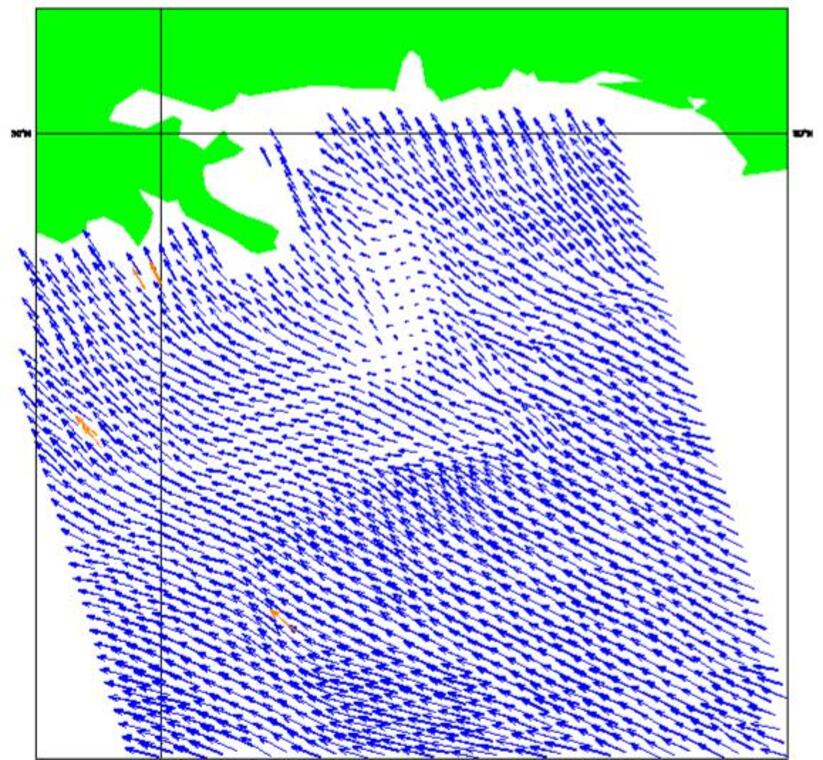
ASCAT coastal product
NOAA staff requested ASCAT winds nearer to the coast in order to better predict the flow of the oil spill towards the coast and as such combat ecological losses due to the oil spill. In swift response to this request the KNMI scatterometer team set up an ASCAT coastal product, which is now presented at www.knmi.nl/scatterometer/ascat_osi_co_prod/ascat_app.cgi .
NOAA is now incorporating the products in their meteorological work stations for operational use and expressed their gratitude for the swift response at KNMI. An example product is illustrated below.
The coastal product is part of the EUMETSAT Ocean and Sea Ice Satellite Application Facility (OSI SAF), see www.osi-saf.org .
ASCAT coastal product in the Gulf of Mexico on 14 May 2010 at 03:38. In the background a GOES infrared cloud image at 03:00 is shown in grey values.
Ook dit jaar ontwaakte de natuur weer vroeg uit haar winterslaap door de hoge temperaturen in feb...
01 mei 2024 - KlimaatberichtGemiddeld was april met een temperatuur van 10,8°C tegen 9,8°C normaal, warm. Maar de maand was o...
30 april 2024 - NieuwsberichtZaterdag viert Koning Willem-Alexander zijn 57ste verjaardag. Hoe is het klimaat tijdens zijn lev...
24 april 2024 - KlimaatberichtHet jaar 2023 was – wederom – een jaar vol extremen in Europa; één van de natste jaren in de meti...
22 april 2024 - Klimaatbericht